Engineering surveying has changed significantly in recent years, thanks to technological advancements and digital innovation. Survey engineers now combine traditional measurement methods with the latest technology, transforming the way construction, infrastructure, and development projects are planned and carried out.
The integration of advanced surveying methods has improved accuracy standards and operational efficiency across various sectors, including:
- Telecommunications infrastructure
- Government construction projects
- Property development
- Utility mapping
- Indigenous land management
Modern survey engineers use advanced tools and techniques that offer both precision and extensive data collection capabilities. These innovations have opened up new opportunities for project planning, execution, and monitoring, while still upholding the core principles of surveying accuracy and reliability.
The evolution of surveying techniques has been particularly beneficial for areas in New South Wales and Queensland, where complex infrastructure projects require more sophisticated methods of land measurement and spatial data collection. This technological shift has made survey engineers crucial to the success of major construction and development projects.
The Role of Survey Engineers in Modern Civil Engineering
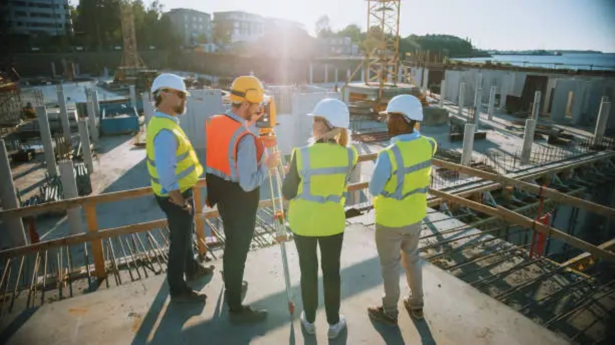
Survey engineers are crucial in today’s civil engineering projects, connecting design ideas with actual construction. These registered surveyors offer essential measurements and spatial information that serve as the groundwork for building infrastructure.
What Do Survey Engineers Do?
Survey engineering involves several key tasks:
- Conducting thorough site investigations before construction begins
- Taking accurate measurements to determine where structures will be built
- Monitoring quality during the construction process
- Creating detailed records of completed work
Collaboration with Utility Locators
In modern projects, survey engineers work closely with utility locators to identify underground infrastructure. This collaboration helps avoid expensive conflicts and ensures safety on-site, making it a standard practice for large-scale infrastructure initiatives.
Professional Services Offered by Survey Engineers
Survey engineers provide a range of professional consulting services, including:
- Creating topographic maps and models of the terrain
- Integrating building information modelling (BIM) into projects
- Conducting boundary and cadastral surveys
- Setting out construction plans and monitoring progress
- Analysing any deformations that may occur
Use of Advanced Technologies
To achieve precise results while adhering to tight project timelines, survey engineers employ cutting-edge technologies. Their skill set goes beyond basic measuring tasks and includes analysing data, creating 3D models, and coordinating various aspects of the project.
Adapting to New Technologies
The role of a survey engineer requires constant adjustment to new tools and methods. This ensures that construction projects can take advantage of the most recent advancements in gathering and interpreting spatial data. As technology evolves, survey engineers are becoming experts in digital data, offering valuable insights for making decisions throughout the project lifecycle.
Key Innovations in Engineering Surveying Techniques
The field of engineering surveying has undergone significant transformation through technological advancements. These innovations have changed the way data is collected, processed, and analysed, allowing for greater accuracy and efficiency in surveying operations.
Advanced Data Collection Systems
New data collection systems have been developed that offer:
- High-precision 3D scanning capabilities
- Real-time data processing
- Integration with cloud-based platforms
- Enhanced accuracy in measurements
- Reduced manual intervention requirements
These systems use advanced technologies such as lasers and cameras to capture detailed information about the surveyed area.
Artificial Intelligence and Machine Learning in Surveying
The integration of artificial intelligence (AI) and machine learning (ML) algorithms has improved the performance of modern surveying equipment. These intelligent systems can:
- Identify patterns in terrain data
- Automatically detect anomalies
- Generate detailed topographic maps
- Rapidly process complex datasets
- Create accurate 3D visualisations
By leveraging AI and ML, surveyors can gain deeper insights from their data and make more informed decisions.
Digital Twin Technology
Digital twin creation has become an essential part of contemporary surveying methods. This innovation enables:
- Virtual representation of physical assets
- Real-time monitoring of structural changes
- Predictive maintenance planning
- Enhanced collaboration between stakeholders
- Improved decision-making processes
Digital twins provide a dynamic view of assets, allowing engineers to simulate scenarios and optimise designs.
Mobile Mapping Systems
The adoption of mobile mapping systems has transformed site documentation processes. These systems combine various sensors to deliver:
- Comprehensive spatial data
- Georeferenced imagery
- Point cloud generation
- Asset condition assessment
- Environmental monitoring capabilities
Mobile mapping allows surveyors to capture large areas quickly and efficiently, reducing the time spent on-site.
Remote Sensing Technologies
Remote sensing technologies have expanded the scope of surveying operations. Modern systems offer:
- Multi-spectral imaging
- Thermal mapping capabilities
- Vegetation analysis
- Subsurface feature detection
- Environmental impact assessment
By using remote sensing, surveyors can gather information from a distance without physically accessing certain areas.
These technological innovations have created new possibilities in data acquisition and analysis. The combination of various surveying techniques provides comprehensive site understanding, enabling more informed decision-making in engineering projects.
UAVs (Unmanned Aerial Vehicles) in Surveying
UAV technology has transformed engineering surveying by enabling quick and affordable aerial data collection. These advanced drones, equipped with high-resolution cameras and sensors, can capture detailed topographic information over large areas in a fraction of the time it would take using traditional surveying methods.
Key Applications:
- Real-time monitoring of construction progress
- Calculating volumes for earthwork projects
- Assessing site planning and development
- Conducting studies on environmental impact
- Inspecting and maintaining infrastructure
The combination of photogrammetry and UAV technology allows for the creation of accurate 3D terrain models and orthomosaic maps. Modern UAV systems achieve accuracy within a few centimetres using RTK (Real-Time Kinematic) positioning, making them suitable for complex engineering projects.
Technical Capabilities:
- Up to 30 minutes of autonomous flight
- Coverage of over 50 hectares per flight
- 4K video resolution
- Thermal imaging capabilities
- Automated flight planning
UAV surveying greatly reduces safety risks by eliminating the need for surveyors to access dangerous or hard-to-reach locations. This technology has proven especially valuable in mining operations, large-scale construction projects, and infrastructure development in the NSW and QLD regions. You may like to visit https://homeiswhatyoumakeit.com/survey-company-services-comprehensive-solutions-for-land-surveying/ to get about Survey Company Services: comprehensive solutions for land surveying.
GNSS (Global Navigation Satellite Systems) Enhancements
Recent advancements in GNSS technology have transformed surveying accuracy and efficiency. Modern GNSS systems use multiple satellite networks – GPS, GLONASS, Galileo, and BeiDou – to provide precise location information within a few centimetres, regardless of the landscape.
Key Benefits of GNSS Enhancements:
- Sub-centimetre accuracy: Real-Time Kinematic (RTK) positioning allows surveyors to achieve measurements with an accuracy of less than one centimetre.
- Faster data collection: With RTK, surveyors can gather data quickly without the need for post-processing, making projects more efficient.
- Increased reliability: The support of multiple satellite constellations ensures a stronger and more dependable signal, reducing the chances of errors.
- Minimized signal interference: Network RTK solutions use cellular networks to transmit correction data, eliminating the reliance on local base stations and minimising potential signal disruptions.
The combination of GNSS technology with inertial measurement units (IMUs) has resulted in powerful positioning solutions for difficult environments such as urban areas with tall buildings (urban canyons) and densely wooded regions. This integration allows for accurate positioning even when satellite signals are temporarily lost, ensuring uninterrupted data collection for survey engineers.
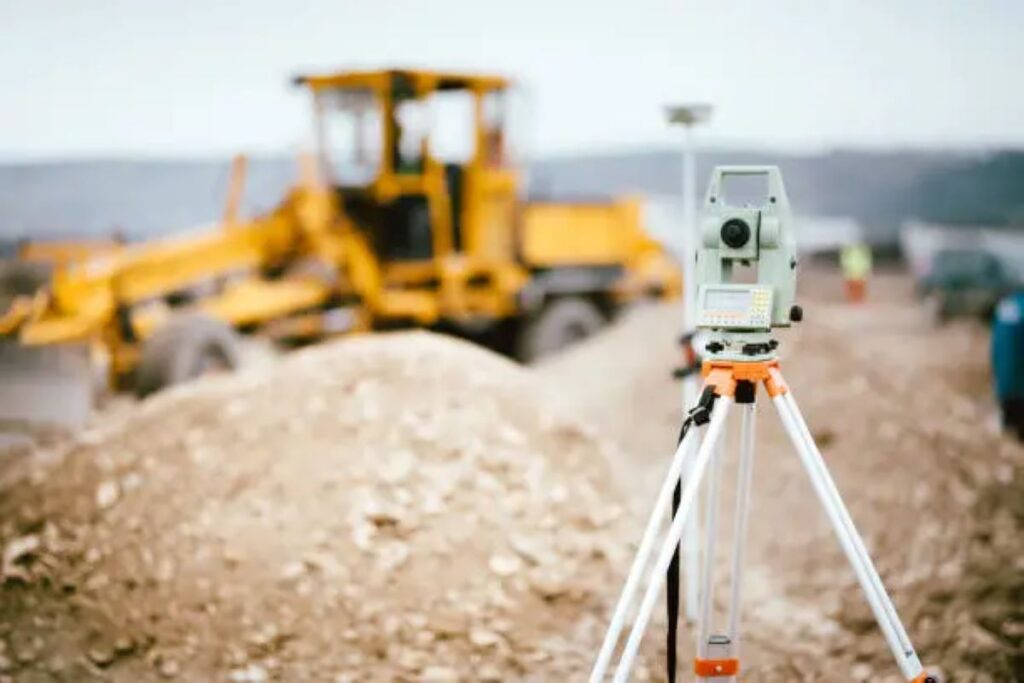
Terrestrial Laser Scanning (TLS)
Terrestrial Laser Scanning is a groundbreaking advancement in high-precision surveying technology. This ground-based system captures detailed 3D measurements through rapid laser pulse emissions, creating dense point clouds of spatial data.
Key capabilities of TLS include:
- Millimetre-level accuracy in capturing complex shapes
- Real-time 3D visualisation of scanned environments
- Non-contact measurement ideal for dangerous or hard-to-reach areas
- Comprehensive data collection at rates of up to 1 million points per second
TLS applications span various engineering projects:
- Building Information Modelling (BIM)
- Monitoring structural deformation
- Documenting heritage sites
- Retrofitting industrial plants
- Analysing tunnel profiles
The technology’s ability to create detailed 3D models enables precise volume calculations, clash detection, and as-built documentation. When combined with specialised software, TLS data supports advanced analyses for structural health monitoring and construction quality control.
Recent developments in TLS systems have introduced improved features like automatic target recognition, enhanced range capabilities, and seamless integration with other surveying tools – expanding its usefulness across the engineering spectrum.

Digitalisation and Rugged Technology in Survey Equipment
Digital transformation has completely changed survey equipment, bringing in advanced tools made for tough outdoor conditions. Robotic total stations are a major leap forward, allowing one person to operate them by automatically following targets and controlling them remotely.
Modern digital surveying tools incorporate:
- Ruggedised tablets with military-grade protection against drops, water, and dust
- Smart data collectors featuring real-time cloud synchronisation
- Advanced software integration for immediate data processing
- Touch-screen interfaces optimised for field operations
These digital innovations have brought remarkable improvements to data collection accuracy and workflow efficiency. Field surveyors now capture, process, and transmit data seamlessly from site to office using integrated systems that withstand challenging environmental conditions.
The latest equipment combines:
- IP68-rated water resistance
- -40°C to +65°C temperature tolerance
- MIL-STD-810G shock resistance
- Anti-glare screens for outdoor visibility
- Extended battery life for full-day operations
This rugged digitalisation enables survey engineers to maintain productivity across diverse project environments, from remote construction sites to urban infrastructure developments.
Immersive Technologies Transforming Survey Data Visualisation
Virtual and augmented reality technologies are changing the way survey data is visualised and understood. These immersive tools create interactive 3D environments that enable stakeholders to experience project sites in unprecedented detail.
Virtual Reality Applications:
- Real-time site walkthroughs
- Spatial relationship analysis
- Underground utility visualisation
- Terrain modelling and earthwork calculations
Augmented Reality Benefits:
- On-site data overlay capabilities
- Real-time measurement verification
- Design conflict detection
- Collaborative decision-making
The integration of Building Information Modelling (BIM) with VR/AR platforms creates comprehensive digital twins of project sites. These virtual environments allow engineers to:
- Identify potential construction challenges
- Simulate different design scenarios
- Conduct virtual site inspections
- Share project insights with stakeholders
The combination of high-precision survey data and immersive visualisation technologies enables more accurate planning, reduced errors, and enhanced communication between project teams. These tools prove particularly valuable for complex infrastructure projects where traditional 2D representations might miss critical spatial relationships.
Impact of Innovations on Project Efficiency and Decision-Making
The integration of advanced surveying technologies has transformed how civil engineering projects are carried out and planned. These innovations bring about significant improvements in various aspects of projects:
Time Efficiency
- 60% reduction in data collection time through automated surveying systems
- Real-time data processing eliminates delays between field surveys and analysis
- Rapid deployment of mobile surveying units reduces project setup time
Cost Benefits
- Decreased labour requirements for routine surveying tasks
- Reduced need for repeat site visits
- Lower equipment maintenance costs through digital solutions
Decision-Making Enhancement
- Data-driven insights enable proactive problem identification
- High-precision measurements reduce error margins to millimetre accuracy
- Risk assessment capabilities through comprehensive site modelling
Project Management Advantages
- Seamless integration with Building Information Modelling (BIM)
- Enhanced stakeholder communication through visualisation tools
- Improved resource allocation through predictive analytics
The adoption of these innovations by firms like Wumara Group has demonstrated significant improvements in project delivery for clients across NSW and QLD markets. Recent telecommunications projects for NBN and Telstra showcase how advanced surveying techniques streamline infrastructure development while maintaining high accuracy standards.
These technological advancements create a ripple effect throughout the project lifecycle, enabling sustainable civil engineering growth through improved efficiency, reduced environmental impact, and enhanced project outcomes. The potential for these innovations extends beyond immediate project benefits, as they also play a crucial role in shaping the future of civil engineering. For instance, the implementation of advanced surveying technologies is not just about improving current practices but also about setting new industry standards that prioritize sustainability and efficiency.
Challenges and Considerations in Adopting New Surveying Technologies
The implementation of advanced surveying technologies presents distinct challenges for engineering firms and practitioners.
1. Substantial Investment Costs
One significant hurdle is the substantial investment costs required for acquiring cutting-edge equipment and software systems. These expenses extend beyond initial purchase to include:
- Regular calibration and maintenance
- Software licensing and updates
- Insurance and security measures
- Backup systems and data storage solutions
2. Training Requirements
Training requirements pose another critical challenge. Survey engineers must develop expertise in:
- Operating sophisticated equipment
- Processing complex data sets
- Interpreting results accurately
- Troubleshooting technical issues
3. Equipment Selection Considerations
The selection of appropriate equipment demands careful consideration of:
- Project-specific requirements
- Environmental conditions
- Accuracy levels needed
- Integration capabilities with existing systems
4. Digital Workflow Integration Complexities
Digital workflow integration creates additional complexities in terms of:
- Data compatibility across platforms
- Network infrastructure requirements
- Cybersecurity protocols
- Quality control procedures
5. Connectivity Issues in Remote Locations
Remote project locations can present connectivity issues, affecting real-time data transmission and cloud-based solutions.
6. Rapid Technological Advancement
The rapid pace of technological advancement also means that equipment can become outdated quickly, requiring strategic planning for future upgrades and replacements.
7. Legal and Regulatory Compliance Challenges
Legal and regulatory compliance adds another layer of complexity, particularly regarding data privacy, storage requirements, and professional certification standards. These factors necessitate ongoing review and updates to operational procedures and risk management strategies.
Future Trends in Engineering Surveying Techniques
The surveying industry is on the verge of significant technological advancements that are expected to transform traditional methods. Here are some key trends to watch out for:
1. Drones and Artificial Intelligence
Advanced drone mapping capabilities are set to integrate artificial intelligence for autonomous flight paths and real-time data processing, enabling surveyors to cover larger areas with unprecedented precision.
2. Evolving LiDAR Technology
High-speed LiDAR modelling technology continues to evolve, with next-generation sensors offering:
- Enhanced point cloud density for ultra-detailed 3D mapping
- Improved penetration through vegetation
- Reduced processing time through edge computing
- Integration with BIM (Building Information Modelling) platforms
3. Cloud-Based Data Management
Cloud-based data management systems are becoming increasingly sophisticated, featuring:
- Real-time collaboration across multiple project stakeholders
- Automated quality control mechanisms
- Machine learning algorithms for pattern recognition
- Predictive analytics for maintenance scheduling
4. Underground Mapping Innovations
The emergence of quantum sensors promises to revolutionise underground utility mapping, while blockchain technology could ensure the immutability and security of survey data. These innovations align with the industry’s shift towards digital twin technology, creating exact virtual replicas of physical assets for enhanced monitoring and maintenance.
5. Enhanced Connectivity with 5G
5G connectivity will enable real-time data streaming from field equipment to office systems, facilitating instant decision-making and reducing project delays.
6. Augmented Reality Applications
The integration of augmented reality with survey data will allow engineers to visualise subsurface utilities and infrastructure directly on-site through smart devices.
These trends are not just fleeting changes but represent a comprehensive shift in engineering surveying practices towards a more efficient, accurate, and secure future.
Case Studies Highlighting Innovation Applications
Recent projects across NSW and QLD demonstrate the practical implementation of innovative surveying techniques in critical infrastructure development:
Telecommunications Infrastructure Project – CI International
- Implementation of advanced GNSS technology for precise network planning
- Utilisation of UAV mapping to assess tower placement locations
- Integration of 3D laser scanning for detailed site documentation
- Achievement of 30% reduction in project timeline through digital workflows
School Infrastructure NSW Development
- Application of mobile LiDAR scanning for comprehensive campus mapping
- Creation of detailed BIM models through point cloud data integration
- Real-time monitoring systems for construction progress tracking
- Successful delivery of accurate as-built documentation for future maintenance
NBN Network Expansion Initiative
- Deployment of underground utility mapping using electromagnetic detection
- Implementation of ground-penetrating radar for subsurface infrastructure
- Creation of detailed 3D visualisations for stakeholder communication
- Reduction of utility strikes by 85% through precise mapping techniques
These case studies highlight the tangible benefits of modern surveying innovations:
- Enhanced project accuracy
- Reduced completion times
- Improved safety outcomes
- Cost-effective solutions
- Comprehensive data collection
- Better stakeholder engagement
The successful execution of these projects demonstrates the vital role of cutting-edge surveying techniques in delivering complex infrastructure developments across Australia’s eastern seaboard.